How it works
An echo sounder is a device to measure the depth of water (or any liquid). An echo sounder sends out sound waves and measures how long it takes for the echo of the sound to come back. The speed of sound in the water is known so that the depth can be calculated.
Results depth measurements using echo sounder or bathymetric surveys can be representedin multiple forms. Most popular are:
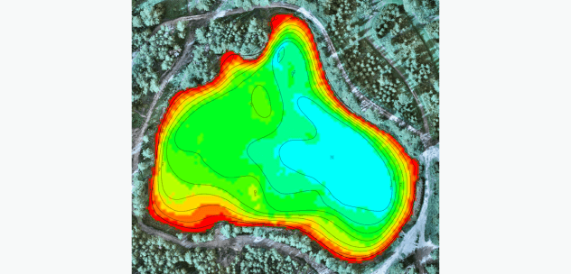
Colored depth or bottom elevation maps and contour maps with isolines of equal depth
(Color-coded map with isolines)

Medium lenCross-section profiles
(Example of lake cross-section)

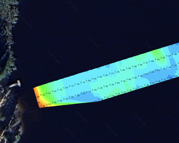
CSV files containing lines consisting of measurement points with coordinates and depth or bottom elevation

Data in the form of point cloud
SPH Engineering offers three standard configurations of the SBES systems, with single and dual-frequency echo sounders
There are multiple different types of devices utilizing echo sounding principle. Single-beam echo sounders (SBES), which may be single-frequency and dual-frequency; multi-beam echo sounders (MBES), scanning sonars, and side-scanning sonars. All these, except SBES, are usually bulky and heavy and not suitable for UAV deployment, at least without a kind of towed buoy.
All sensors are manufactured by Korean company EofE Ultrasonics Ltd., specializing in survey-grade sonar products.
Single-frequency echo sounder with an acoustic frequency of 450kHz
It measures the distance till the first “obstacle” in the water - sediments, seaweeds, and even fish. Therefore, if the bottom of the survey area is covered with seaweed, this basic configuration may not work for such a case.
The measured depth will fluctuate erratically depending on what echo sounder received reflected sound - bottom or vegetation. That means that to get “clean” readings from ECT 400S the bottom should be without seaweeds.
The benefit of ECT 400S is that it has a very short dead zone of 15cm - a minimum distance it can measure. That makes the system with ECT 400S suitable for very shallow surveys, starting from approximately 30cm deep.

Dual-frequency echo sounder with an acoustic frequency of 450 and 200 kHz
Technically, a dual-frequency echo sounder is two types of devices with different acoustic frequencies combined in a single compact casing.
The higher frequency is the same, 450 kHz, and it will give measurements till the first surface or obstacle. The lower frequency is 200 kHz, and sound with that frequency will pass through seaweeds/vegetation on the bottom, and the device will report clean readings of the bottom.

The graph illustrates how technology works
The red line is the reflection from the first obstacle for 450 kHz sound - jumping between seaweeds and bottom, but the green line (readings for 200 kHz) gives consistent depth measurements.
Note that the dead zone for 200 kHz is 0.5m, limiting the minimum practical survey depth for
that device by approx 0.8m.

The graph demonstrates the technology: the red line reflects 450 kHz sound, fluctuating between seaweed and the bottom, while the green line (200 kHz) provides steady depth measurements
Dual-frequency echo sounder with an acoustic frequency of 200 and 50 kHz
200 kHz sound impulses will reflect from the top surface of the bottom, but 50 kHz sound can penetrate through organic or light sediments, measuring the depth till the hard bottom.
That creates the possibility of mapping the depth and measuring the depth and amount of sediments in the water body.
The dead zone for 50 kHz is 1m, and the minimum practical survey depth will be around 1.2m.

Tell us more about the place you want to examine and its conditions
And we will help you choose the best option

Benefits of echosounder with UAV
The echo sounder is the standard measurement tool for bathymetry (depth measurement). Usually, the survey process involves using a ship, boat, or unmanned surface vehicle (USV) as a platform for the sensor.
Sometimes, the use of a boat can be complicated, especially in the case of small
or hard-to-reach rivers and lakes. The use of USV is not feasible in every situation either.
Firstly
it is necessary to have a good point of entry to the water for deployment/recovery.
Secondly
using USV in shallow lakes with lots of seaweed may be impossible
Last but not least
in many cases, a USV should be big enough to resist the waves, and a big car may be necessary to transport it.
The UAV is a good alternative for carrying the echo sounder
A drone is compact and easy to transport and deploy. Drones also have a high precision of following planned survey lines and can be used anywhere where there is at least a small area for take-off and landing near the surveyed water surface.
Hard-to-reach locations
The UAV system is ideal for hard-to-reach locations (steep coasts, mining pits, shallow waters, terrain obstacles), as well as waters of ponds, lakes, and canals. There is no need for an entry point to the water for deployment and recovery. There are applications where the surveyed area was a few hundred meters from the take-off location.
2 times more cost-efficient
For small water bodies or survey areas, the mobilization cost for the boat or USV with bathymetric equipment may exceed the survey's price. Highly portable UAV system saves time for mobilization and deployment and may be up to 2 times more cost-efficient than a standard approach using a ship, a boat, or a USV.
Works in a hazardous environment
The system works in a hazardous environment, which humans cannot approach freely. A drone operates without water contact. Therefore, lakes and rivers with strong currents, as well as contaminated waters, become measurable.
Precise positioning
The drone's precise positioning while following the survey routes and ability to fly at a constant speed and specified low altitudes result in high-accuracy measurements.
Typical applications
Physically, disregarding applications, echo sounders will measure the same. However, applications may dictate survey planning, data processing, and final reporting differences. Below is the list of typical applications for the drone-borne echo sounder systems:


Tell us about your case
And we will help you select the appropriate echo sounder for your application
System components
The echosounder system for UAV consists of multiple components listed below. For your convenience, all necessary components, software, and services are combined into bundles for different types of echo sounders.
Compatible with DJI M300/M350/M600, Inspired Flight IF1200A, Harris Aerial H6, and Wispr Ranger Pro and similar drones

Accuracy
of the system

Image representing the correlation between drone-mounted system with echo sounder and measurement pole with Trimble RTK GNSS receiver (in red circles)
In bathymetry, traditionally dominated by boats, there is a growing presence of UAV-based solutions incorporating echo sounders for bathymetric data collection. That raises the normal questions about the accuracy of the system.
As the UAV-borne system uses survey-grade echo sounders and hi-end RTK GNSS receivers of the modern drones for the positioning, the accuracy of the data collected using drone-mounted systems is the same as for manned and unmanned boats.
Our customers compared data collected using drones with more traditional methods. The image below is a track of the data from the drone collected using a measurement pole with Trimble RTK GNSS receiver (in red circles), data courtesy of Geopartner Landinspektorer A/S. That method of measurement is considered to be the most precise. It is visible that the difference is negligible.